This years PanoTools Meeting took place in Messina, Italy. This panorama shows the meeting venue on the first day, short before the meeting started. The PanoTwins presented their talk about how to use spherical panoramas aka Photo Spheres in the Google universe. See the two posts here and here.
[pano file=”https://www.panotwins.de/wp-content/panos/MMatern_20130902_0015_PTM2013_MeetingVenue01.xml” preview=”https://www.panotwins.de/wp-content/panos/MMatern_20130902_0015_PTM2013_MeetingVenue01.jpg”]
 Show on map
Tag: Sony NEX 6
Articles related to the Sony NEX 6 camera. This includes panoramas stitched directly with the camera (so called sweep panoramas) and panoramas stitched with PTGui.
Baoleskopf Viewpoint near the Summit Cross (Google Embedded Version)
This panorama was shot near the summit of mount Baoleskopf.
Between Bergächtle and Wiedemerkopf
This panorama has been made at the beginning of the trail to one of the highest mountains in the Allgäu. It is the Hochvogel, with a height of 2592m.
[pano file=”https://www.panotwins.de/wp-content/panos/MMatern_20130817_9363_HochvogelblickBach.xml” preview=”https://www.panotwins.de/wp-content/panos/MMatern_20130817_9363_HochvogelblickBach.jpg”]
Show on map
Baoleskopf Viewpoint near the Summit Cross
This panorama was shot near the summit of mount Baoleskopf.
[pano file=”https://www.panotwins.de/wp-content/panos/MMatern_20130816_9328_BaoleskopfVorKreuz.xml” preview=”https://www.panotwins.de/wp-content/panos/MMatern_20130816_9328_BaoleskopfVorKreuz.jpg”]
Show on map
Viewpoint near Iseler summit
This panorama shows a nice viewpoint near the summit of mount Iseler. You see to the valley of Bad Hindelang and also towards Oberjoch. The hardest part in getting to the viewpoint is the way from the mountain station of the Iseler cable car.
[pano file=”https://www.panotwins.de/wp-content/panos/MMatern_20130815_9198_IselerAussichtsunkt.xml” preview=”https://www.panotwins.de/wp-content/panos/MMatern_20130815_9198_IselerAussichtsunkt.jpg”]
Show on map
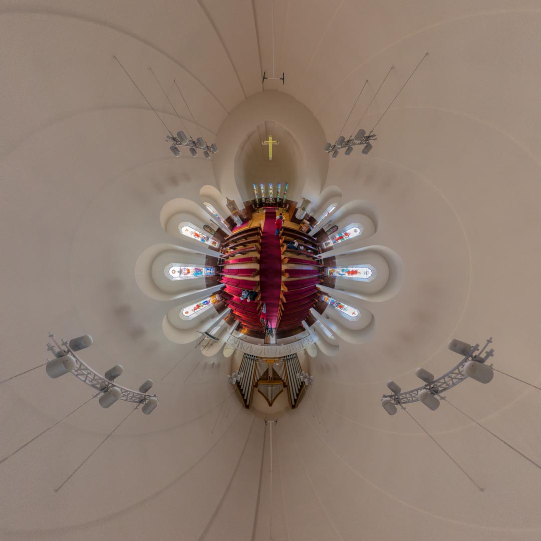
Reprojected Akureyrarkirkja – Inside
This image shows a stereographic reprojection of this panorama.
Show on map
Reprojected Akureyrarkirkja – Outside
This image shows a stereographic reprojection of this panorama.
Ófærufoss in Eldgjá Canyon
This panoram shows Ófærufoss in Eldgjá canyon which is not easy to reach. You better have a 4×4 at hand because it is far away from Iceland’s main road! It can only be reached by an F- road and then by foot.
[pano file=”https://www.panotwins.de/wp-content/panos/MMatern_20130625_8261_OfaerufossRocks.xml” preview=”https://www.panotwins.de/wp-content/panos/MMatern_20130625_8261_OfaerufossRocks.jpg”]
Show on map
Stranded Iceberg at Jökulsárlón
Jökulsárlón is a lagoon in Iceland and the place where the Breiðamerkurjökull ends. Small icebergs from the Vatnajökull can so reach the sea. However depending on the winds they sometimes strand on the beach like this one.
[pano file=”https://www.panotwins.de/wp-content/panos/MMatern_20130624_8069_Iceberg.xml” preview=”https://www.panotwins.de/wp-content/panos/MMatern_20130624_8069_Iceberg.jpg”]
Show on map
Old and rusty crane
This panorama shows an old and rusty machine. In better times it surely was a trusty machine but now it’s only rusty…
I also used this panorama for the WWP event ‘machines’. You can find my original publication here.[pano file=”https://www.panotwins.de/wp-content/panos/JMatern_130623_8016-8025_RM.xml” preview=”https://www.panotwins.de/wp-content/panos/JMatern_130623_8016-8025_RM.jpg”]
Show on map