Jesuitenkirche in Heidelberg

This image shows the Jesuitenkirche in Heidelberg (Germany).

Geotag Icon Show on map


Technique:
The shooting was done with a 3 meter (appx. 10 ft) pole to reach a more elevated viewpoint. The lens was mounted with a custom-made bracket. Stitched from five images taken with a Walimex (Samyang) 7.5mm fish eye lens on a Sony ILCE-QX1. Four images around and an additional image for the floor.

Historic Windmill at Hessenpark

This panorama shows a historic windmill at the Hessenpark (an open air museum in Hesse, Germany).

Geotag Icon Show on map


Technique:
The shooting was done with a 3 meter (appx. 10 ft) pole to reach a more elevated viewpoint. The lens was mounted with a custom-made bracket. Stitched from five images taken with a Walimex (Samyang) 7.5mm fish eye lens on a Sony ILCE-QX1. Four images around and an additional image for the ground.

Demolition Works

This panorama shows the demolition of a building in Frankfurt am Main.

Geotag Icon Show on map


Technique:
The shooting was done with a 3 meter (appx. 10 ft) pole to reach a more elevated viewpoint. The lens was mounted with a custom-made bracket. Stitched from five images taken with a Walimex (Samyang) 7.5mm fish eye lens on a Sony QX1. Four images around and an additional image for the nadir. The zenith was retouched by hand in post-processing.

Pinakothek der Moderne

This image shows the northern entrance of the museum Pinakothek der Moderne in Munich (Germany).

Geotag Icon Show on map


Technique:
The shooting was done with a 3 meter (appx. 10 ft) pole to reach a more elevated viewpoint. The lens was mounted with a custom-made bracket. Stitched from five images taken with a Walimex (Samyang) 7.5mm fish eye lens on a Sony ILCE-QX1. Four images around and an additional image for the ground.

Allen Lambert Galleria – Reprojections

Upon seeing the unique structure of Allen Lambert Galleria for the first time in a panoramaic image I wanted to take my own one. I tried to find a spot which is as centered in the structure as possible, because one of my goals was to create reprojections of the spherical image. Here are the results:

Allen Lambert Galleria - Transverse Mercator
Allen Lambert Galleria – Transverse Mercator

Geotag Icon Show on map


Heading for Planes and Trains

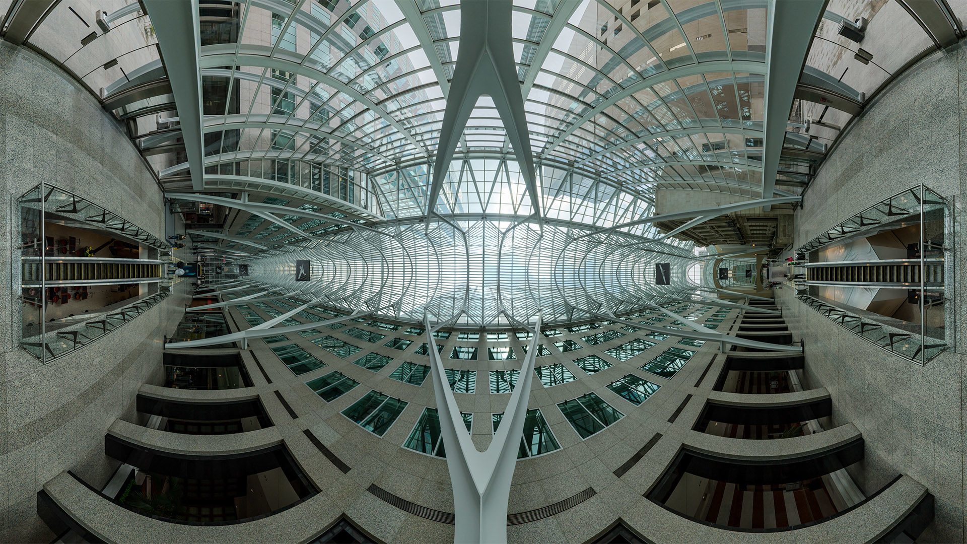
The long-distance train station at the airport of Frankfurt/Main is one of 5.400 train stations in Germany. It’s operated by the German railroad company Deutsche Bahn. The station went into service 1999. It measures approx. 700 m. in length, 50 m. in width and 45 m. in height. The station is divided into two main levels. The trains operate on the lower level, the passengers can change tracks and head to the airport via the upper level (distribution level). The large glass dome, which spans the distribution level is clearly visible in the panorama.

Outside the dome you can see The Squaire, which currently (2016) is Germany largest office building. It was built between 2006 and 2010 on top of the existing train station.

Geotag Icon Show on map


Technique:
The shooting was done with a 3 meter (appx. 10 ft) pole to reach a more elevated viewpoint. The lens was mounted with a custom-made bracket. Stitched from five images taken with a Walimex (Samyang) 7.5mm fish eye lens on a Sony QX1. Four images around and an additional image for the nadir. The zenith was retouched by hand in post-processing.

Viehscheid in Bad Hindelang

This panorama shows the “Viehscheid” in Bad Hindelang. The german noun “Viehscheid” translates to “separation of cattle”. It is is an annual event in the alpine regions of southern Germany. During summer, the cattle feeds on alpine grazing land high up in the mountains. This land is called Almen or Alpen. In autumn the cattle is brought back into the valleys and the cows are separated from the herd and picked up by their respective owners.

[pano file=”https://www.panotwins.de/wp-content/panos/JMatern_150911_6990-6994_FS.xml” preview=”https://www.panotwins.de/wp-content/panos/JMatern_150911_6990-6994_FS.jpg”]
Geotag Icon Show on map


Technique
The shooting was done with a 3.20 meter (appx. 10.5 ft) pole to reach a more elevated viewpoint. The lens was mounted with a custom-made bracket. Stitched from five images taken with a Walimex (Samyang) 7.5mm fish eye lens on a Sony QX1. Four images around and an additional image for the nadir. The zenith was retouched by hand in post-processing.

QR Code Business Card